The following electronic version is for informational purposes only.
The printed version remains the official version.
Certified correct as passed Third Reading on the 7th day of November, 2007
Ian D. Izard, Q.C., Law Clerk
APPENDIX Q
HIGHWAY 17 CORRIDOR
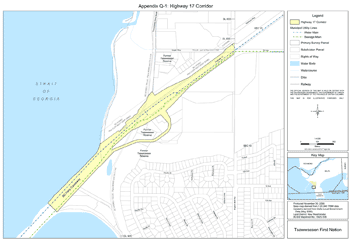
| APPENDIX Q-1 | Map of Highway 17 Corridor |
| APPENDIX Q-2 | List of Public Utility Works within Highway 17 Corridor |
APPENDIX Q-1
Map of Highway 17 Corridor
APPENDIX Q-2
Public Utility Works Within the Highway 17 Corridor
Note: Information will be updated before the Effective Date.
| Interest Holder | Interest | Location | Document Reference Number |
|---|---|---|---|
| British Columbia Hydro and Power Authority | (1) Right-of-Way for electric power transmission and distribution lines; (2) Lease for cable landing facilities |
Along the north side of Highway 17, through Former Tsawwassen Reserve | OCPC 1978-283 (Can)
FNLRS2 1833-32 |
| British Columbia Hydro and Power Authority/Telus Communications Inc. (formerly BC Tel) | (1) Easement for electric power transmission line; (2) Permit for Telephone lines | Crosses Highway 17, through Former Tsawwassen Reserve | FNLRS 7572-248 CLSR Plan M3683 |
| Telus Communications Inc. (formerly BC Tel) | Aerial and underground permit for telephone lines | Intersects with Highway 17 at Tsawwassen Rd. & 16th Ave. | FNLRS 103640 Telus Drawing No. CX-0-1150 |
| Corporation of Delta | Municipal Water and Sewage Mains | Along the south side of Highway 17 to the BC Ferries causeway, through Former Tsawwassen Reserve | Engineering drawings on file with the Corporation of Delta |
| 2 FNLRS - First Nation Land Register System 3 LTO - Land Title Office |
|||