The following electronic version is for informational purposes only.
The printed version remains the official version.
Certified correct as passed Third Reading on the 2nd day of June, 2011
Ian D. Izard, Q.C., Law Clerk
APPENDIX F
YALE FIRST NATION LAND DESIGNATED AS AN AGRICULTURAL LAND RESERVE
| Part 1 | Parcel Descriptions of Yale First Nation Land Designated as an Agricultural Land Reserve |
| Part 2 | Map of Yale First Nation Land Designated as an Agricultural Land Reserve |
Part 1: Parcel Descriptions of Yale First Nation Land Designated as an Agricultural Land Reserve
Note: the Parties will update the Appendices before the Effective Date
| Part 1 | ||
| Parcel Description | Area of Yale First Nation Land designated as an Agricultural Land Reserve |
Land Title Office Parcel Identifier |
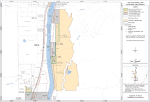
| That portion of Squeah District Lot 50 Yale Division of Yale District except (1) Parcels A, B and C shown on Plan B366 and (2) DD159953F, identified in Appendix F, Part 2 as "Agricultural Land Reserve" (Area 1) | 12.21 hectares | Portion of 002-677-334 |
| Portion of NE ¼ lying East of Indian Reserve 7 Kaykaip, Section 22, Township 6, Range 26, West of the 6th Meridian, Yale Division of Yale District identified in Appendix F, Part 2 as "Agricultural Land Reserve" (Area 2) | 0.20 hectares | Not currently registered in Land Title Office |
| Portion of the SE ¼, lying east of the Fraser River and East of Indian Reserve 7 Kaykaip, except Section 22, Township, 6, Range 26, West of the 6th Meridian, Yale Division of Yale District, except thereout Plan A529 identified in Appendix F, Part 2 as "Agricultural Land Reserve" (Area 3) | 7.12 hectares | Not currently registered in Land Title Office |
| Those portions of SW ¼ lying south of Stulkawhits Creek of Section 15, Township 6, Range 26, West of the 6th Meridian, Yale Division of Yale District except Block A, identified in Appendix F, Part 2 as "Agricultural Land Reserve" (Area 4) | 3.14 hectares | Not currently registered in Land Title Office |
Part 2: Map of Yale First Nation Land Designated as an Agricultural Land Reserve
Appendix: F, Part 2
Agricultural Land Reserve