The following electronic version is for informational purposes only.
The printed version remains the official version.
APPENDIX F
YALE FIRST NATION LAND DESIGNATED AS AN AGRICULTURAL LAND RESERVE
| Part 1 | Parcel Descriptions of Yale First Nation Land Designated as an Agricultural Land Reserve |
| Part 2 | Map of Yale First Nation Land Designated as an Agricultural Land Reserve |
Part 1: Parcel Descriptions of Yale First Nation Land Designated as an Agricultural Land Reserve
Note: the Parties will update the Appendices before the Effective Date
| Part 1 | ||
| Parcel Description | Area of Yale First Nation Land designated as an Agricultural Land Reserve |
Land Title Office Parcel Identifier |
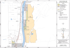
| That portion of Squeah District Lot 50 Yale Division of Yale District except (1) Parcels A, B and C shown on Plan B366 and (2) DD159953F, identified in Appendix F, Part 2 as "Agricultural Land Reserve" (Area 1) | 12.21 hectares | Portion of 002-677-334 |
| Portion of NE ¼ lying East of Indian Reserve 7 Kaykaip, Section 22, Township 6, Range 26, West of the 6th Meridian, Yale Division of Yale District identified in Appendix F, Part 2 as "Agricultural Land Reserve" (Area 2) | 0.20 hectares | Not currently registered in Land Title Office |
| Portion of the SE ¼, lying east of the Fraser River and East of Indian Reserve 7 Kaykaip, except Section 22, Township, 6, Range 26, West of the 6th Meridian, Yale Division of Yale District, except thereout Plan A529 identified in Appendix F, Part 2 as "Agricultural Land Reserve" (Area 3) | 7.12 hectares | Not currently registered in Land Title Office |
| Those portions of SW ¼ lying south of Stulkawhits Creek of Section 15, Township 6, Range 26, West of the 6th Meridian, Yale Division of Yale District except Block A, identified in Appendix F, Part 2 as "Agricultural Land Reserve" (Area 4) | 3.14 hectares | Not currently registered in Land Title Office |
Part 2: Map of Yale First Nation Land Designated as an Agricultural Land Reserve
Appendix: F, Part 2
Agricultural Land Reserve